News | SCAG's Lyle Janicek Enables Virtual Exploration of Global Transit Systems
Stop the VideoNews
SCAG's Lyle Janicek Enables Virtual Exploration of Global Transit Systems
Wednesday, December 23, 2020
by Dan Lamere, USC, Masters of Urban Planning 2021
While the global pandemic may discourage travel to destinations worldwide, transit enthusiasts and researchers can now virtually explore the world of urban rail transit, thanks to a new global transit database, the World Rail Network.
The World Rail Network (WRN) was developed as a side project by Lyle Janicek, an Associate Regional Planner at the Southern California Association of Governments (SCAG). WRN’s Databases and Dashboards can be explored through Lyle’s website, WorldRailNetwork.com, where users can find geospatial data attributes from 322 transit systems, covering 280 cities in 73 different countries across the globe. The term “transit systems” here primarily refers to urban rail and excludes regional rail but includes some commuter rail systems like Southern California’s Metrolink.

Lyle Janicek, creator of the World Rail Network
Through the website’s Dashboards, which Lyle developed using Esri’s ArcGIS Dashboards feature, users can quickly view transit system maps accompanied by a myriad of data points, including annual ridership, number of operational stations, city population, and population density. This tool can be used by researchers to quickly compare critical geospatial data points between transit systems in different cities and countries. For transit enthusiasts, it is a fun tool to explore, to see how your favorite transit system compares to other systems, and to learn about how transit systems operate in cities throughout the world.
Lyle hopes to add even more functionality and data points to this project in the future, including ridership changes over time, fares for each system, station locations relative to the streetscape (e.g., elevated, at-grade, or sub-surface), and station types (island, side, etc.). In the longer-term, Lyle also plans to incorporate historical information about systems that have been closed, such as the Pacific Electric Railway Company, aka the Red Cars which terminated in 1961, in Los Angeles. These additions to the Dashboards would provide even more valuable information to explore for researchers and transit enthusiasts alike, providing a more comprehensive picture of the world’s past and present urban rail network.
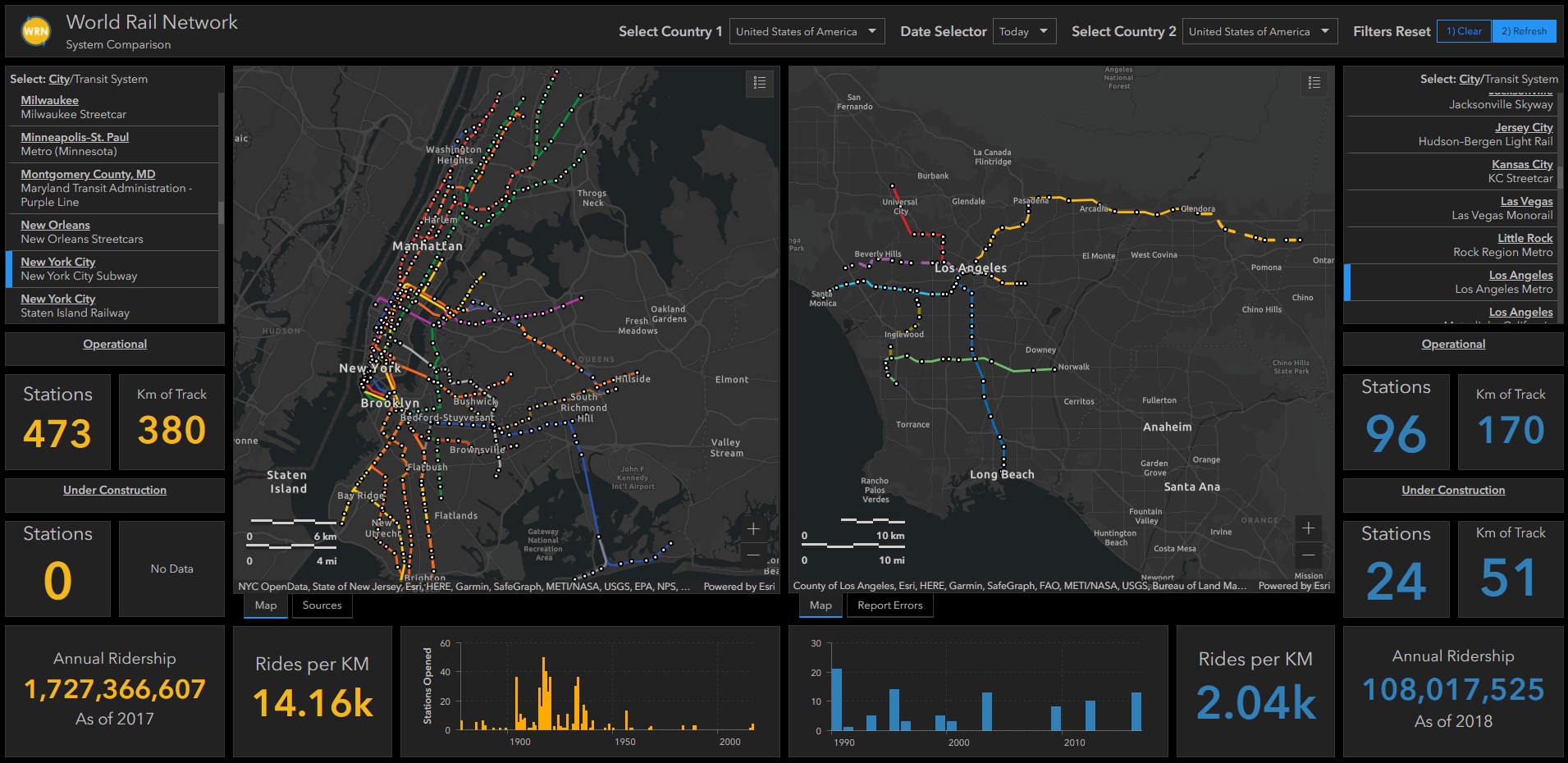
Image of the Dual System Dashboard on WorldRailNetwork.com
Growing up in a small, one-stoplight town in Western Nebraska, Lyle’s hometown offered a Dial-a-Ride service as the sole alternative to single occupancy vehicle (SOV) travel. Once he realized that many places outside of Western Nebraska offered alternatives to a car-dependent lifestyle, he developed a fascination with rail networks through his academic coursework and life experiences, which drew him all over the world . Lyle has traveled and experienced coveted transit systems up close and personal, including those in places like New York City, Beijing, Shanghai, and Tokyo. It was during and after these journeys that he sought to learn more about how cities are integrating dense urban environments with transit infrastructure, and his curiosity led him to continue to explore rail networks on a global scale.
Lyle earned his bachelor’s degree from the University of Nebraska, Lincoln, in Landscape Architecture and began his career working for a landscape architecture firm in Riverside, California, where he specialized primarily in park planning. He eventually decided to pursue a master’s degree in Urban and Regional Planning from Cal Poly Pomona where, through his thesis, he assessed projected ridership for the Los Angeles County Metropolitan Transportation Authority’s (LA Metro) rail network and measured these projections against actual ridership data.
It was also through this research that his idea for the WRN was born. When trying to compare LA Metro’s system to other heavy and light rail systems like San Francisco’s Bay Area Rapid Transit (BART) and the San Diego Trolley, Lyle found that each had unique GIS (Geographic Information System) features. This lack of consistency made it challenging to analyze and compare data across transit systems – it was like comparing apples to oranges.
“It was at this time I decided to learn the basics of ArcGIS Pro and other apps while creating a database of rail transit systems,” Lyle stated. “Two years later, the database grew to feature more than 320 systems, from over 280 cities. It became an interesting hobby as I was learning about various elements of rail transit from around the world, all while refining my GIS skills.“
He learned the basics of GIS through coursework both as an undergraduate and graduate student and recommends for students looking to build their GIS skills to complement any formal training with other resources, such as online tutorials through YouTube and Esri, like he did.
Lyle Janicek anticipates continually expanding and enhancing his World Rail Network database and is always incorporating feedback from users to improve the data and dashboards. The WRN is a unique tool for those interested in transit to quickly access information through a very user-friendly and visually-appealing platform.
Click here to visit the website or click here to contact Lyle with any questions or suggestions.
About the Author:
Dan Lamere is a second-year Master of Urban Planning student at the USC Price School of Public Policy. He works as a staff writer and project coordinator for the METRANS student team.
News Archive
- December (1)
- November (6)
- October (4)
- September (2)
- August (3)
- July (4)
- June (3)
- May (7)
- April (8)
- March (11)
- February (8)
- January (7)
- December (7)
- November (8)
- October (11)
- September (11)
- August (4)
- July (10)
- June (9)
- May (2)
- April (12)
- March (8)
- February (7)
- January (11)
- December (11)
- November (5)
- October (16)
- September (7)
- August (5)
- July (13)
- June (5)
- May (5)
- April (7)
- March (5)
- February (3)
- January (4)
- December (4)
- November (5)
- October (5)
- September (4)
- August (4)
- July (6)
- June (8)
- May (4)
- April (6)
- March (6)
- February (7)
- January (7)
- December (8)
- November (8)
- October (8)
- September (15)
- August (5)
- July (6)
- June (7)
- May (5)
- April (8)
- March (7)
- February (10)
- January (12)
2024
2023
2022
2021
2020
2019
2018
2017
2016
2015
2014
2013
2012
2011
2010
Major Funders


Metrans Associate Partners