News | METRANS, PSR, USC UP host Boeing for Global Urban Street Network Models and Indicators Webinar
Stop the VideoNews
METRANS, PSR, USC UP host Boeing for Global Urban Street Network Models and Indicators Webinar
Wednesday, November 11, 2020
by Hayley Rundle, USC, Masters of Urban Planning 2022
On October 27, METRANS, the Pacific Southwest University Transportation Center (PSR), and special partner, the University of Southern California’s (USC) Undergraduate Planning at Price organization (UP), launched the fourth and final research webinar for the Fall 2020 webinar series. UP is a student-led organization at USC Price for anyone interested in urban planning. UP’s vision is to build a community of equity-oriented undergraduate students, promote academic and professional development, foster critical dialogue, and provide relevant programming for undergraduate students, in particular, at Price.
At the webinar, titled “Street Network Models and Indicators for Every Urban Area in the World,” Dr. Geoff Boeing showcased his ongoing research. Boeing is an Assistant Professor of Urban Planning and Spatial Analysis at the Price School of Public Policy and the Director of USC’s Urban Data Lab.
The motivation for Boeing’s research lies in capturing the wealth of information that can be gathered from street networks. Boeing describes street networks as providing a connective tissue to organize human dynamics and to look across different urban forms at fine-grain and course-grain levels. Street networks also provide insight into how politics, expression of power, privilege, and exclusion are planned into different street networks around the world. Overlaying features with the street network allows planners and researchers to understand how street networks percolate and how networks are resilient or susceptible to disasters.

Dr. Geoff Boeing
“It is interesting to see the street layout of streets in cities from coast to coast are, which reflects the history and culture of each city,” noted Yougeng Lu, Ph.D. candidate in Urban Planning and Development at USC Price.
For his research, Boeing uses OSMnx, a software package he developed himself to characterize travel and connectivity. OSMnx stands for OpenStreetMap + NetworkX, and is similar to if Wikipedia and Google Maps merged. OSMnx uses OpenStreetMap (OSM), a free, collaborative world map, to create maps of urban areas that include roads, intersections, public transit routes, informal circulation paths, and bicycle infrastructure. The purpose of the software package is to easily download, model, and analyze street networks that are publicly available for anyone to use or contribute to. With OSMnx, users can download and model OSM street networks; perform algorithmic correction and processing of network topology; download building footprints, points, of interest data, and elevation data; conduct analyses such as calculate geometric and topological network indicators; and more.
“I have been following the development of OSMnx for a while now, and it has been exciting to watch the software’s feature set expand over time,” said Tiernan Martin, Livable Communities Program Manager at Futurewise. “I am encouraged by Professor Boeing’s commitment to open science and free and open source software (FOSS), and I hope it will allow his work to help bridge the gap between the mathematicians who develop network science methods and the urban planning practitioners who shape the design of actual street networks.”
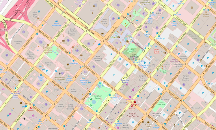
Map of Downtown Los Angeles from OSMnx.
Boeing shared some of his most recent work modeling street networks of the entire US at multiple scales looking at each city, urban area, county, census tract, and Zillow neighborhood. Using OSMnx, Boeing calculated dozens of indicators for each urban street network and then deposited the models and indicators in an open data repository. Networks indicators include network geometry and network topology, which both explain network interconnections and relationships to one another. Through his research, he is able to demonstrate empirical findings on US urban form and street network characteristics, emphasizing models related to graph theory, transportation, urban design, and morphology such as structure, correctness, density, centrality, and resilience.
Boeing then dove into his current research, which aims to model street networks for every urban area in the world by using each urban area in the Global Human Settlement Layer (GHSL) database. Similar to modeling street networks of the entire US, Boeing calculated dozens of indicators for each street network using OSMnx and then deposited the models, indicators, and code in a public, open data repository. With the worldwide street networks project, Boing attached elevation to every node and calculated edge grades using ASTER, SRTM3, and Google Elevation API. Boeing was able to study the orientation order or disorder (entropy) of a street network on a worldwide scale and determine which urban areas followed a more grid-like street network pattern and which did not, and if urban areas in the same region had similar entropies.
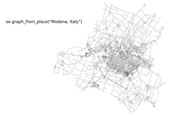
A line of code used to plot a specific urban area street network and the resulting street map of Modena, Italy.
By examining street networks on a worldwide scale, Boeing has also been able to predict transport CO2 emissions as a function of street networks and other covariates. These covariates include average node degree, meaning how many streets are connected; straightness aka the measure of efficiency of a road network; and intersect density, which refers to how fine-grained the network is; per capita street length – how much road infrastructure there is in an urban area per person; and night light emissions. This research analyzing worldwide street networks is still in progress and is expected to be completed in December 2020.
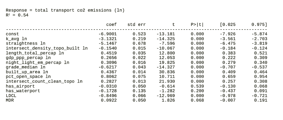
Total transport CO2 emissions for a street network and the covariates used to predict emissions.
To close his presentation, Boeing emphasized the need to make street network analyses easier for planners, circling back to the open source nature of OSMnx – which allows planners to conduct analyses using little to no coding knowledge. Boeing’s work has already impacted transportation planners in the field, including those without technical background.
Tom Vo, Senior Regional Planner at SCAG noted, “The presentation delivered by Professor Boeing was informative and easy to understand. I believe it was not too technical so that was also good for those with non-technical backgrounds. I’m always a big fan of utilizing programming and visualization to effectively tell stories while ensuring data accuracy and validity. At SCAG, we are actively and progressively apply[ing] programming languages (e.g. Python, SAS, R, etc.) for many projects (e.g. transit, housing, environmental justice, sustainability, etc.).”
Boeing underscored the need for planning to incorporate people’s lived experiences, specifically those of marginalized communities, and how models can be used to bring more voices into the discussion. To close, Boeing reaffirmed his support for the open science movement and his motivations to make OSMnx a public, open source software. “Too often researchers will conduct a study and not share the code, data, etcetera,” Boeing pointed out, “but the more open source these materials are, the more efficient science can be and build upon what has been created.”
On behalf of UP, Co-President and USC Price undergraduate Lilly Nie shared that UP was “extremely grateful for the opportunity to collaborate with METRANS and also wanted to give a big thank you to Professor Boeing for his insightful presentation on urban street networks. This event provided a unique platform for engaging with faculty that our student organization has never explored before during this virtual time. I think it's a format that is worth reexploring in the future, especially considering how online events can often feel more impersonal when Q&A is handled solely through chat.”
We’d like to extend our sincere gratitude to Professor Geoff Boeing for his presentation, and for his commitment to equitable data sourcing and accessibility within urban planning.
We encourage you to watch the full or highlight reels, or review the presentation slides by using this link.
About the Author:
Hayley Rundle is a first-year Master of Urban Planning student at the USC Price School of Public Policy, concentrating in Mobility and Transportation Planning. She is interested in sustainable transportation planning to improve environmental quality, equity, and mobility for all. Hayley serves as the team leader for the METRANS Industry Engagement and contributes to the Student Research Team, summarizing cutting edge transportation research projects and findings for the upcoming METRANS Fast Facts for Students series.
News Archive
- December (1)
- November (6)
- October (4)
- September (2)
- August (3)
- July (4)
- June (3)
- May (7)
- April (8)
- March (11)
- February (8)
- January (7)
- December (7)
- November (8)
- October (11)
- September (11)
- August (4)
- July (10)
- June (9)
- May (2)
- April (12)
- March (8)
- February (7)
- January (11)
- December (11)
- November (5)
- October (16)
- September (7)
- August (5)
- July (13)
- June (5)
- May (5)
- April (7)
- March (5)
- February (3)
- January (4)
- December (4)
- November (5)
- October (5)
- September (4)
- August (4)
- July (6)
- June (8)
- May (4)
- April (6)
- March (6)
- February (7)
- January (7)
- December (8)
- November (8)
- October (8)
- September (15)
- August (5)
- July (6)
- June (7)
- May (5)
- April (8)
- March (7)
- February (10)
- January (12)
2024
2023
2022
2021
2020
2019
2018
2017
2016
2015
2014
2013
2012
2011
2010
Major Funders


Metrans Associate Partners